HEALTH
Use our resources to better understand the importance of mapping to public health.
Teachers, scroll down for a short list of key resources in our Teachers’ Toolkit.

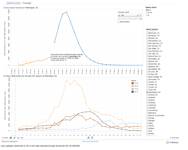
Map by Mailman School of Public Health, Columbia University

Map by Mailman School of Public Health, Columbia University
Discussion Ideas
- Read through our terrific activity “Mapping a London Epidemic.” What are the major differences between the map created by Dr. John Snow (detailed in the activity) and the map created by the good folks at Columbia University (detailed in the CNN article)?
- The most profound difference is that Snow working backwards, tracing a disease to its likely source. The new Columbia map is looking forward, or forecasting, the likely pattern of how a disease will spread in the future.
- The disease Snow was studying, cholera, is much more rare in industrialized nations than most seasonal strains of influenza (the flu), the disease studied by the health researchers at Columbia.
- Snow was mapping incidents of disease in a single London neighborhood. The Columbia researchers are mapping incidents of disease across (almost) and entire country. (“Almost” because perennial outliers Alaska and Hawaii are not mapped.)
- What variables do you think the health researchers considered when making their flu forecasting map?
- real-time reports of flu cases from doctors, hospitals, and other health-care centers (where are people getting the flu?)
- traditional models based on historic data of flu reports (where and when were people getting the flu last year?)
- What other data might make the map even more accurate?
- geography. Where and when are people getting the flu outside the United States?
- purchases. Where and when are consumers buying health medicines?
- school attendance records. Where and when are students not going to school due to illness?
- Wikipedia and Google. Where and when are people searching for specific health-related information? Read more about how my second-favorite website (Wikipedia) is helping researchers—and its limits. Check out Google Flu Trends to see their estimates of flu activity.
- Twitter. Using social media may be an even more accurate and valuable tool in helping predict the spread of the flu—read about how researchers (and app developers) are using social media to help improve models.
- apps: This app says: “Just as Doppler radar scans the skies for indicators of bad weather, Sickweather scans social networks for indicators of illness, allowing you to check for the chance of sickness as easily as you can check for the chance of rain.”
- travel. Thousands of people travel during the holidays, and may expose fellow passengers on planes, trains, and automobiles. Cities that are hubs for traffic may need to take precautions during the busy travel-flu season.
- Read more about how big data might help health care in this article from Hospitals & Health Networks.
- How might the predictive flu map help people?
- Hospitals and health-care facilities in certain areas may anticipate the need for extra beds, staff, medicines, flu vaccines, and safety or sanitation equipment.
- Retail stores and pharmacies may be able to stock up on over-the-counter medications and flu vaccines.
- Parents may want to keep their children home from school or extracurricular activities during their region’s peak flu season.
- People may want to work from home or schedule time off during their region’s peak flu season.
- Perhaps more than anything, forecasts may remind people to modify their behavior during peak flu season:
- get a flu vaccine
- wash your hands frequently
- avoid touching your eyes, nose, or mouth
- get plenty of sleep
- get plenty of exercise
- drink plenty of fluids
- manage your stress
- eat healthy foods
- cover your mouth and nose when you cough and sneeze
- if you’re sick already, STAY HOME if you can
TEACHERS TOOLKIT
CNN: Predicting the flu so you can avoid it
Nat Geo: Mapping A London Epidemic
Mailman School of Public Health, Columbia University: Influenza map and forecast
CDC: What You Should Know for the 2014-2015 Influenza Season
Los Angeles Times: Scientists use Wikipedia search data to forecast spread of flu
Fast Company: When is Flu Season? How Twitter Beats Google to the Answer
Sickweather: Sickweather Map
Flu.gov: Prevention

